


|
You are at Home » Segara Anak Lake
|
|


Rinjani 2.0Rinjani 2.0 Segara Lake Rinjani By Handjono August 2008 – Four CopiPanas members hike this idylic mountain. For CopiPanas, this is the second time we make a trip to the top of Lombok Island. And this is our story. When seated in row 18 onboard Garuda GA-430 Airlines, I was still wondering if my decision was right to climb the mighty Rinjani. For it is 3726 M, steep, treacherous-and-slippery-near-the-top and ice-cold, and I will be 50 in less than 2 months, that’s why. Well, it was too late. The stewardess has already closed the airplane door. One hour 45 minutes later we landed in Selaparang airport of Mataram. Four of us, Budiyono, Luki, Masood and me, were met by Ruslan, the driver from the Trek Organizer. Mataram was cloudy when we rode the car from Selaparang Airport to Hero Supermarket to buy breads and drinks. Then we drove through Pusut forested hills, and Ruslan told us stories around the re-emerging tourism in Lombok after many years of dimmed lights on the island’s west coast. Along the roads the grey haired monkeys sat wisely on the tree branches and by the roadside amidst the shower that wetted the road. Then the road descends to the lowland of open area with abundant cashew trees. We saw some ladies sold sate-ikan along few kilometers close to Bayan Village, but we were too busy discussing Lombok and Rinjani to make a stop. By the time we wanted to try sate-ikan, there was none anymore. We must have that sate-ikan on the way back, for I know in my heart they must be just delicious.
By 7:00 our gears and logistics are packed on a pickup car. The well-built Suzuki Carry took 9 of us, with 2 sitting on top with some luggage. Yes, on top of the back roof. An hour of meandering road, first descending to Bayan Village and then ascending to Sembalunlawang where we registered ourselves at the National Park Office. Then back to the Bawaknao Village a few km down the road. Departing from Bawaknao (900 M) saves climbers 1 hour of hot and dusty savannah trail.
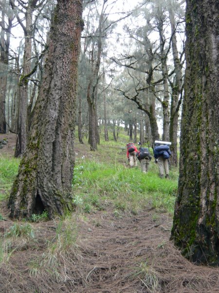
Bawaknao to Post-1 was 1 hour, hot and dusty as we expected. There was a 15 minutes of shades when we walked across a small group of grown up big trees, with monkeys jumping from branch to the others. Then it came the hot savannah again. The t-shirts were very soon wetted by the sweats of the thirsty trekkers. The porters walked in front of us swaying with the heavy carriers of tents, sleeping bags, foods, water etc. Eggs were contained in a soft egg-shaped wrapper tied on top of all the other stuffs. All were balanced into 2 and mounted on both ends with a 3 feet bamboo resting on the shoulder of the porters. We wondered how many eggs would survive this trek to the top. Post-1 was a shelter amidst the hot yellowish green savannah. The stop was literally seat, drink, chat and sleep. A 15 minutes sleep and another 15 minutes for muscle stretching were so precious after a sleepless night in Senaru. Then, on we marched to Post-2, still trekking along the savannah, crossing several concrete bridges. The bridges must have been there for the planned road crossing the national park’s savannah. Thanks to the villagers who refused the plan.
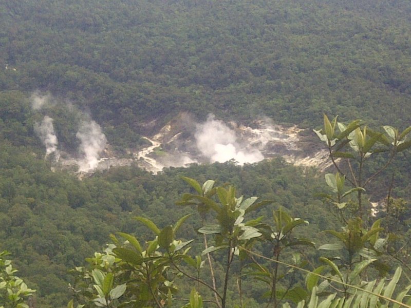
Very soon the mildly ascending trail became very steep, must be at least 30° in average. In some places the ascents must have been 45° or even more. Fortunately, the soil was hard and not slippery at all. Our muscles worked so hard, all out to reach the Plawangan Sembalun Crater Rim. The picture of warm fire and sweet hot tea were dancing in my mind, helping me negotiating the ever steep Bukit Penyesalan. It was 3.5 hours of precipitation amidst the cold and wet air on 2000 M+. When we reached the Plawangan Sembalun by 17:45, there were already many trekkers’ camps. The bright colors looked beautiful from a distance. Some trekkers sat by the rim looking quietly at the looming Segara Anak Crater Lake. Really eerie scenery to the Segara Anak Crater Lake, 600 M down there. The dinner was big, bigger than we could eat. Some long haired long tailed grey monkeys were always present, watching us having dinner in the hope we would spare some. But we did not for we know they would be spoiled and would come closer from time to time. Very soon we found ourselves in the tent, in the warmth of our jackets, double hulled trousers and double socks. Do not forget the gloves before slipping into the sleeping bag. And all bags and shoes inside the tents, beware of monkeys. We ignored the almost full moon in order to prepare ourselves for the final ascent the next morning. We knew it would be tough.
Getting colder and colder we slowly marched towards the south-east where the peak is located. Now the terrain changes to unconsolidated gravel. The ascent has become steeper towards 30° degree + and Anom, our guide sought cover behind a large standing rock, where we spent 15 minutes of nice doze. The lights from the trekker’s headlamps were twinkling far above us, somewhat brighter than the stars. Once every a while I looked up and realize the peak is still there. It did not come closer, so I had to climb and crawl for now the gravel has become “one step up 2/3 steps down”. Very slow, albeit my exploration on stepping and crawling techniques. It must have been 3500 M when the sun rose in the east. The warm beautiful yellow ray very soon ignited my soul to make the final ascent. It looked close to the 3726 M, the peak of dream of amateur climbers like us. Believe me the 226 M looked so close for it is always >45° degree ascending. So close but so hard. Just 30 minutes from the very peak a young lad gave up for the gravel was so uncompromising to his torn mall model shoes…. 🙂 By 7:30 I was the last person arriving at the peak, joining my 2 colleagues and Anom the guide.
By 8:00 we marched down the peak. I have never been skiing in my life but it must be like what we did. We simply kept ourselves standing while sliding down one foot after the other. The gorges to the left were a little bit scary, to the right it was gently sloping with edelweiss bushes all over it. Very quickly we came to the leveled fine sand narrow trail. Then some meandering gravel trail amidst the hot dry air. Only 1:45 hours going down from the peak to the Plawangansembalun camp compared to the 5 hours going up. Now you can imagine how steep and tough it was when we went up. Back in the camp area most of the camps have gone and several new ones were being erected by the porters. The Plawangansembalun looked totally different from yesterday afternoon. No more laughs and crowds, the sound of pine trees blown by the easterly wind dominated the air. One hour sleep before a hefty brunch, then a struggle to finish the big brunch of pancakes, toasts and fruits. Do not leave a plate of any food on it because the long haired monkey will be more than ready to snatch it. They are spoiled careless trekkers who leave foods, thus developing the taste for modern human foods. Continue Reading Rinjani 2.0 to Page: [1] [2]More Stories on Climbed VolcanoesRinjaniJourney to Jewel of the Ring of Fire
 Gili Trawangan Sunrise By CopiPanas Team September 2005 – Hiking Mount Rinjani is quite a challange. To reach the peak and visit the Segara Anak Lake requires 3 days and 2 nights hiking through 35 km long trails with various difficulties. The most difficult one is the last km to reach its top, where the slope is very steep and the trail is consist of loose gravels. Managing logistics and timely pace are also essential to hike this mountain. Many thanks to our local hiking guide, Cemplung, and porters that help makes our trip this time enjoyable and save. We started hiking from Sembalun Lawang Village in early morning to reach the Plawangan Sembalun 1st. campsite. It is a relatively gentle slope but very long trail through a vast savanna plain. After break for lunch at Pos 3, we continued walk in a steeper trail through the pine forest. We set tent at Sembalun Lawang campsite that evening, after an exhausting climb.
We had a very rewarding view. From here, almost all Lombok coast line can be seen. The peak of Mount Agung in Bali and Tambora in Sumbawa are also visible. And the most spectacular view is the Rinjani crater-lake itself with new volcano of Mount Barujari raising from the lake. A really unique and beautiful volcano!
That night we had special menu for diner, which is the fresh carpers from the lake. We bought the fish from the local fisherman who spent days staying in this lake with couples of his friends. We grilled and fried the fish, and they were very tasty.
From here, we decent to Senaru Village as our last point of hiking and reach the village by afternoon. Different than Sembalun trail, the track to Senaru is fully covered with dense rain forrest. CopiPanas – Volcanolovers in Indonesia
More Stories on Climbed Volcanoes |


